Royal Arch (structure)
The Royal Arch was erected in Dundee, Scotland, between 1849 and 1853 to commemorate a visit to the city by Queen Victoria and her husband, Prince Albert, in 1844.
The Royal Arch was erected in Dundee, Scotland, between 1849 and 1853 to commemorate a visit to the city by Queen Victoria and her husband, Prince Albert, in 1844.
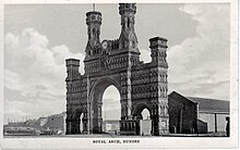
The Royal Arch, (described as being in the "Anglo-Norman" style), consisted of a large, triumphal arch, flanked by two smaller side arches, and surmounted by two central turrets. It was 80 feet across. Costing somewhere between £2,270.00 and £3,000.00, it was mostly funded by public subscription and harbour trustees. It was situated between King William IV Dock and Earl Grey Dock on the south side of Dock Street between the junctions of Castle Street, and Whitehall Crescent.
Victoria and Albert were on a visit to Duke of Atholl and his nephew, Lord Glenlyon (who succeed the unmarried duke 2 years later); the royal boat landed at the Royal Arch; the couple returned and embarked for London on 1 October 1844. This was the first visit by a British monarch to Dundee since the 17th century. The original arch (designed by harbour engineer, James Leslie) was made out of wood. John Thomas Rochead, designer of the Wallace Monument near Stirling designed a permanent sandstone monument to replace the wooden structure.
The Royal Arch, (commonly known in Dundee as Victoria Arch), was demolished on 16 March 1964, as part of the land reclamation scheme, and to make way for the construction of the Tay Road Bridge. The arch was dynamited, and the rubble thrown into both the King William IV and the Earl Grey Docks. Afterwards, the docks were land-filled to accommodate the slip roads for the new road bridge.
A cast bronze model of the arch is situated outside the east entrance to the Overgate Centre in the middle of the city. The arch was also used symbolically by Stevel Holl Architects in their unsuccessful bid to build the annex of Victoria and Albert Museum to be located on the banks of the River Tay. A famous photograph of the arch taken by noted photojournalist Michael Peto in 1959, is held by the archive services of University of Dundee and is available to view online.
Coordinates: 56°27′34″N 2°58′04″W / 56.45944°N 2.96778°W / 56.45944; -2.96778
The Royal Arch was erected in Dundee, Scotland, between 1849 and 1853 to commemorate a visit to the city by Queen Victoria and her husband, Prince Albert, in 1844.
The Royal Arch was erected in Dundee, Scotland, between 1849 and 1853 to commemorate a visit to the city by Queen Victoria and her husband, Prince Albert, in 1844.
The Royal Arch, (described as being in the "Anglo-Norman" style), consisted of a large, triumphal arch, flanked by two smaller side arches, and surmounted by two central turrets. It was 80 feet across. Costing somewhere between £2,270.00 and £3,000.00, it was mostly funded by public subscription and harbour trustees. It was situated between King William IV Dock and Earl Grey Dock on the south side of Dock Street between the junctions of Castle Street, and Whitehall Crescent.
Victoria and Albert were on a visit to Duke of Atholl and his nephew, Lord Glenlyon (who succeed the unmarried duke 2 years later); the royal boat landed at the Royal Arch; the couple returned and embarked for London on 1 October 1844. This was the first visit by a British monarch to Dundee since the 17th century. The original arch (designed by harbour engineer, James Leslie) was made out of wood. John Thomas Rochead, designer of the Wallace Monument near Stirling designed a permanent sandstone monument to replace the wooden structure.
The Royal Arch, (commonly known in Dundee as Victoria Arch), was demolished on 16 March 1964, as part of the land reclamation scheme, and to make way for the construction of the Tay Road Bridge. The arch was dynamited, and the rubble thrown into both the King William IV and the Earl Grey Docks. Afterwards, the docks were land-filled to accommodate the slip roads for the new road bridge.
A cast bronze model of the arch is situated outside the east entrance to the Overgate Centre in the middle of the city. The arch was also used symbolically by Stevel Holl Architects in their unsuccessful bid to build the annex of Victoria and Albert Museum to be located on the banks of the River Tay. A famous photograph of the arch taken by noted photojournalist Michael Peto in 1959, is held by the archive services of University of Dundee and is available to view online.
Coordinates: 56°27′34″N 2°58′04″W / 56.45944°N 2.96778°W / 56.45944; -2.96778

20